
UC Berkeley SafeTREC recommends strategies for safe routes to school in El Cerrito

Students after school at Korematsu Middle School.
A safety assessment focused on safe routes to school for students attending West Contra Costa Unified School District schools in northern El Cerrito recommends a range of street infrastructure improvements and traffic calming measures.
El Cerrito/Richmond Annex Walk & Roll applied to UC Berkeley’s Safe Transportation Research and Education Center (SafeTREC) for the free Complete Streets Safety Assessment (CSSA), which provides technical assistance to communities for creating safe spaces for people to walk and bike.
The 104-page report, “El Cerrito/Richmond Annex Complete Streets Safety Assessment: Issues, Opportunities, and Suggested Strategies,” covers Madera Elementary School, Arlington Boulevard, Korematsu Middle School, the Ohlone Greenway, San Pablo Avenue, and El Cerrito’s proposed East Side Bicycle Boulevard.
“Key long-term improvements include installing a separated cycle track or ‘school street’ on Donal Avenue along the Korematsu Middle School frontage, widening sidewalks to create a pedestrian walkway on Arlington Boulevard south of Madera Elementary School, and installing a bikeway connection across San Pablo Avenue, the report concludes.
A second report, funded by a grant from the Metropolitan Transit Commission and expected in the coming months, will look at safe routes to schools in southern El Cerrito, including Fairmount and Harding elementary schools, and El Cerrito High.
Key findings
Conducted by the consulting firm Fehr & Peers, the CSSA is structured around three key activities: 1) Reviewing historical crash data and trends with a focus on crashes involving people walking and biking; 2) Conducting a comprehensive benchmarking assessment of policies, programs, standards, and guidelines; and 3) Conducting a complete streets field audit at
Crash data and trends. From 2019 to 2023, 54 crashes involving pedestrians or bicyclists were reported in the City of El Cerrito and Richmond Annex, including one fatal crash and ten serious injury crashes. Of the total number of crashes, 22 percent occurred on state roads — primarily San Pablo Avenue.
Benchmark policy analysis. The report’s benchmark analysis identified areas where El Cerrito’s street safety and bicycle planning exceeded, met, or did not meet national best practices. Areas where El Cerrito exceeded national best practices included setting speed limits, proactively enhancing crosswalk safety, integrating safe systems principles into transportation policies, and having a Complete Streets policy in place.
At the same time, the report noted that El Cerrito fell short of national best practices in a few key areas: The city does not have a communitywide Safe Routes to School program, transportation advisory committee, or traffic calming/speed management program; and only reactively implements proven safety countermeasures at signalized intersections. It also found that El Cerrito’s active transportation plan is out of date and none of the bike facilities recommended by the plan have been implemented in recent years.
Field audit. A field audit was conducted on May 13, 2025, to assess and document existing conditions, conducted in collaboration with the CSSA stakeholder team, which included City of El Cerrito staff, community members, and local parents and students to ensure a thorough and comprehensive evaluation of local pedestrian and bicyclist needs and conditions.
The report includes detailed recommendations to support safe routes to school for elementary and middle school students in El Cerrito and Richmond Annex, including speed management, traffic calming strategies, and bicycle and pedestrian gap closures. These include crossing strategies such as the installation of rectangular rapid-flashing and pedestrian-hybrid beacons, curb extensions, pedestrian refuges, and raised crosswalks.
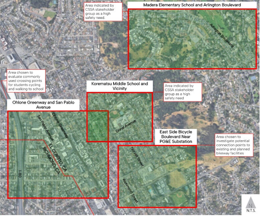
Project study area for the UC Berkeley SafeTREC Complete Streets Safety Assessment of safe routes to public schools in northern El Cerrito.
Caption: Study area for El Cerrito/Richmond Annex Complete Streets Safety Assessment
Safe routes to school
General recommendations to improve street safety around public schools in northern El Cerrito, as well as along the Ohlone Greenway and San Pablo Avenue, included:
Implementing speed management tools to reduce the severity of collisions near schools.
Closing sidewalk gaps, especially on Arlington Boulevard for safer pedestrian access to Madera School.
Enhancing safety at controlled and uncontrolled crosswalks.
Installing bikeways and connection points to achieve a safe, connected network accessible to all ages and abilities.
UC Berkeley SafeTREC’s recommendations are aligned with Contra Costa Transportation Authority’s Countywide Toolbox for Designing Safer Travel for People Walking and Bicycling and Caltrans’ Complete Streets design guidance.
“Bicycle boulevards with traffic calming elements are also proposed between schools and the Ohlone Greenway and the planned Richmond Street bike lanes to provide a connected network,” the report notes.